Close

This site uses cookies. No personal data is stored. You can read how we use them in our cookies policy. Continuing on this site accepts their use. Thankyou.

Viewing swaag.org website implies consent to set cookies on your computer. Full details Swaledale and Arkengarthdale Archaeology Group
Registered Charitable Incorporated Organisation Number 1155775
SWAAG Honorary President:
Tim Laurie F,S,A,

Another Search

Scroll down the record
 *****SWAAG_ID***** 353
 Date Entered 25/11/2011
 Updated on 12/12/2011
 Recorded by Tim Laurie
 Category Mining Related
 Record Type Mining
 Site Access Public Access Land
 Record Date 20/04/2010
 Location Fell End
 Civil Parish Arkengarthdale
 Brit. National Grid Hidden
 Altitude 386m
 Geology Kame terrace below the Main Limestone
 Record Name Bale site with lead prill below Fell End.
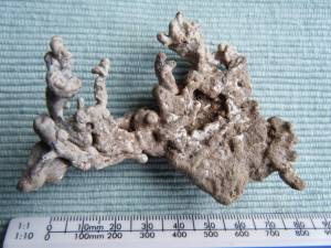
 Record Description Lead bale visible as erosion patch with slag and lead prill. See photo. One of several lead bales on the westerly facing scarp slopes of below Fremington Edge and Fell End.
 Image 1 ID 1422         Click image to enlarge
 Image 1 Description Lead prill from bale site, Fell End.
 
Another Search